We can’t wait to welcome you to Download XXII. We’ve been working closely with local authorities to develop this travel plan and kindly ask that you follow guidance below to get everyone on site as quickly as possible.
This guide covers:
- Which car park to head to based on where you’re camping.
- What directions to follow, depending on where you’re coming from.
- When car parks open.
- Which car park you should use based on ticket type.
How to use this guide:
- Please find your colour-coded route on the local area map – designated by your ticket type and the direction that you are coming from.
- You can then find in the table underneath a link which will take you to the starting point of the colour-coded route on the map.
- Once you get to your colour coded route start point, please then follow the roadside event signage based on your ticket type, pointing to Download Festival.
- It is important that you follow the festival signage at this point and don’t attempt to use alternative routes, or use alternative Sat Nav destinations.
Remember there may be road closures, roadworks or congestion that isn’t picked up by Sat Navs so please follow event signage as you near the festival. For real time updates, follow our travel updates page, National Highways Travel updates and download our festival app.
Camping Tickets Driving Routes
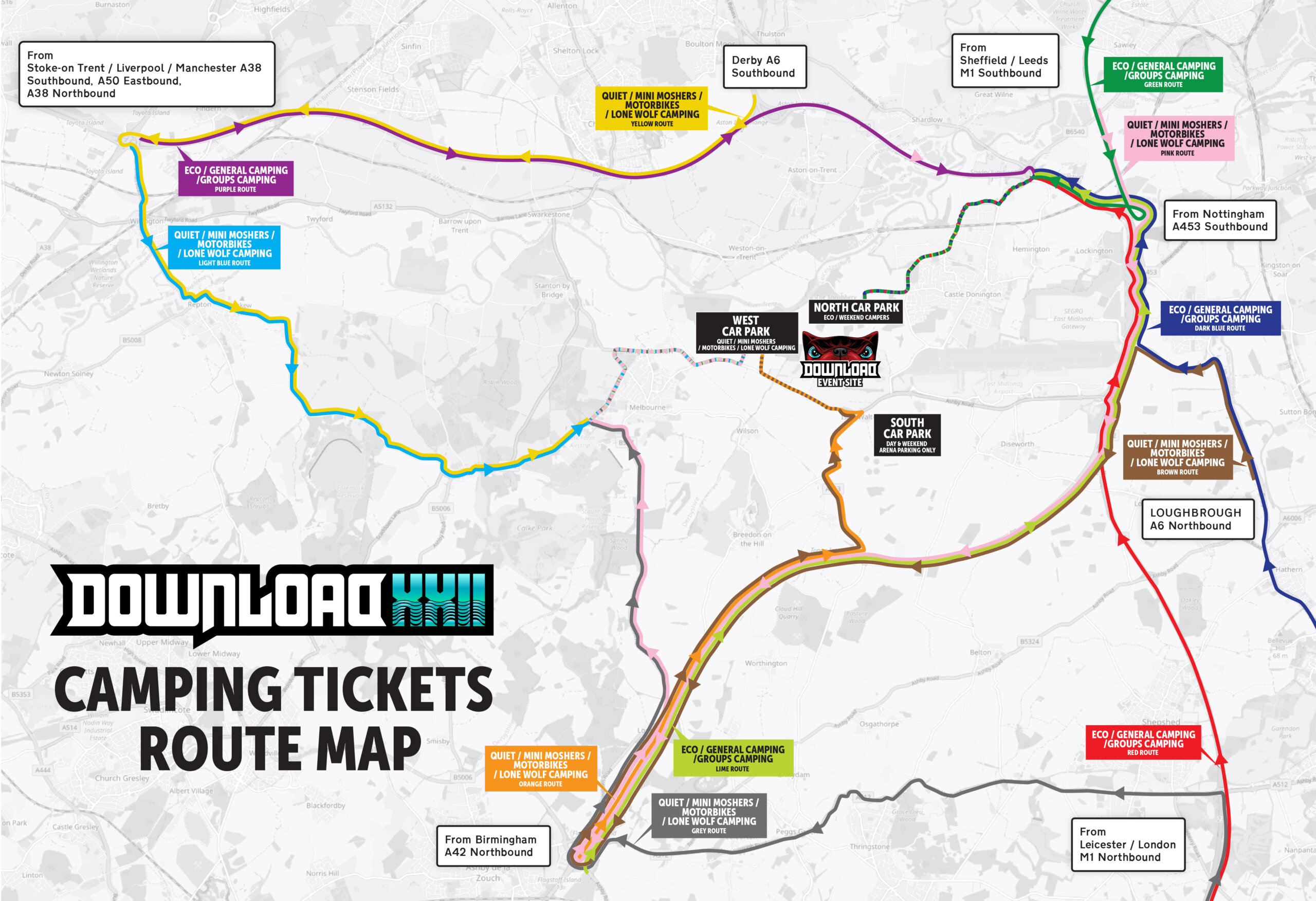
General, eco & group camping
| Travelling from... | Route colour | Head to general, eco and group camping |
|---|---|---|
| The Northwest via Stoke-on-Trent / Liverpool / Manchester (A38 Southbound / A50 Eastbound / A38 Northbound) | Purple | Apple Maps / Google Maps |
| Derby via A6 Southbound | Purple | Apple Maps / Google Maps |
| The North via Sheffield / Leeds / M1 Southbound / A1 Southbound | Green | Apple Maps / Google Maps |
| The Northeast via Nottingham / A543 Southbound | Red | Apple Maps / Google Maps |
| The Southeast via Loughborough / A6 Northbound | Dark blue | Apple Maps / Google Maps |
| The South via Leicester / London / M1 Northbound | Red | Apple Maps / Google Maps |
| The Southwest & Midlands via Birmingham (A42 Northbound) | Lime | Apple Maps / Google Maps |
Quiet, mini moshers, motorbike & lone wolf camping
| Travelling from... | Route colour | Head to quiet, mini moshers, motorbike & lone wolf camping |
|---|---|---|
| The Northwest via Stoke-on-Trent / Liverpool / Manchester (A38 Southbound / A50 Eastbound / A38 Northbound) | Light blue | Apple Maps / Google Maps |
| Derby via A6 Southbound | Yellow | Apple Maps / Google Maps |
| The North via Sheffield / Leeds / M1 Southbound / A1 Southbound | Pink | Apple Maps / Google Maps |
| The Northeast Via Nottingham / A543 Southbound | Pink | Apple Maps / Google Maps |
| The Southeast via Loughborough / A6 Northbound | Brown | Apple Maps / Google Maps |
| The South via Leicester / London / M1 Northbound | Grey | Apple Maps / Google Maps |
| The Southwest & Midlands via Birmingham (A42 Northbound) | Orange | Apple Maps / Google Maps |
Day Tickets & Weekend Arena Driving Routes
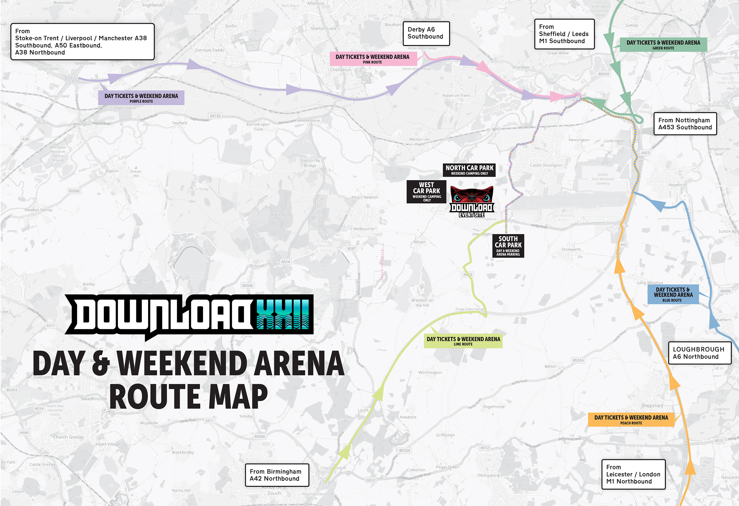
| Travelling from... | Route colour | Head to the day & weekend arena |
|---|---|---|
| The Northwest via Stoke-on-Trent / Liverpool / Manchester (A38 Southbound / A50 Eastbound / A38 Northbound) | Purple | Apple Maps / Google Maps |
| Derby via A6 Southbound | Pink | Apple Maps / Google Maps |
| The North via Sheffield / Leeds / M1 Southbound / A1 Southbound | Green | Apple Maps / Google Maps |
| The Northeast via Nottingham / A543 Southbound | Peach | Apple Maps / Google Maps |
| The Southeast via Loughborough / A6 Northbound | Blue | Apple Maps / Google Maps |
| The South via Leicester / London / M1 Northbound | Peach | Apple Maps / Google Maps |
| The Southwest & Midlands via Birmingham (A42 Northbound) | Lime | Apple Maps / Google Maps |
Accessibility Camping and Campervan Driving Routes
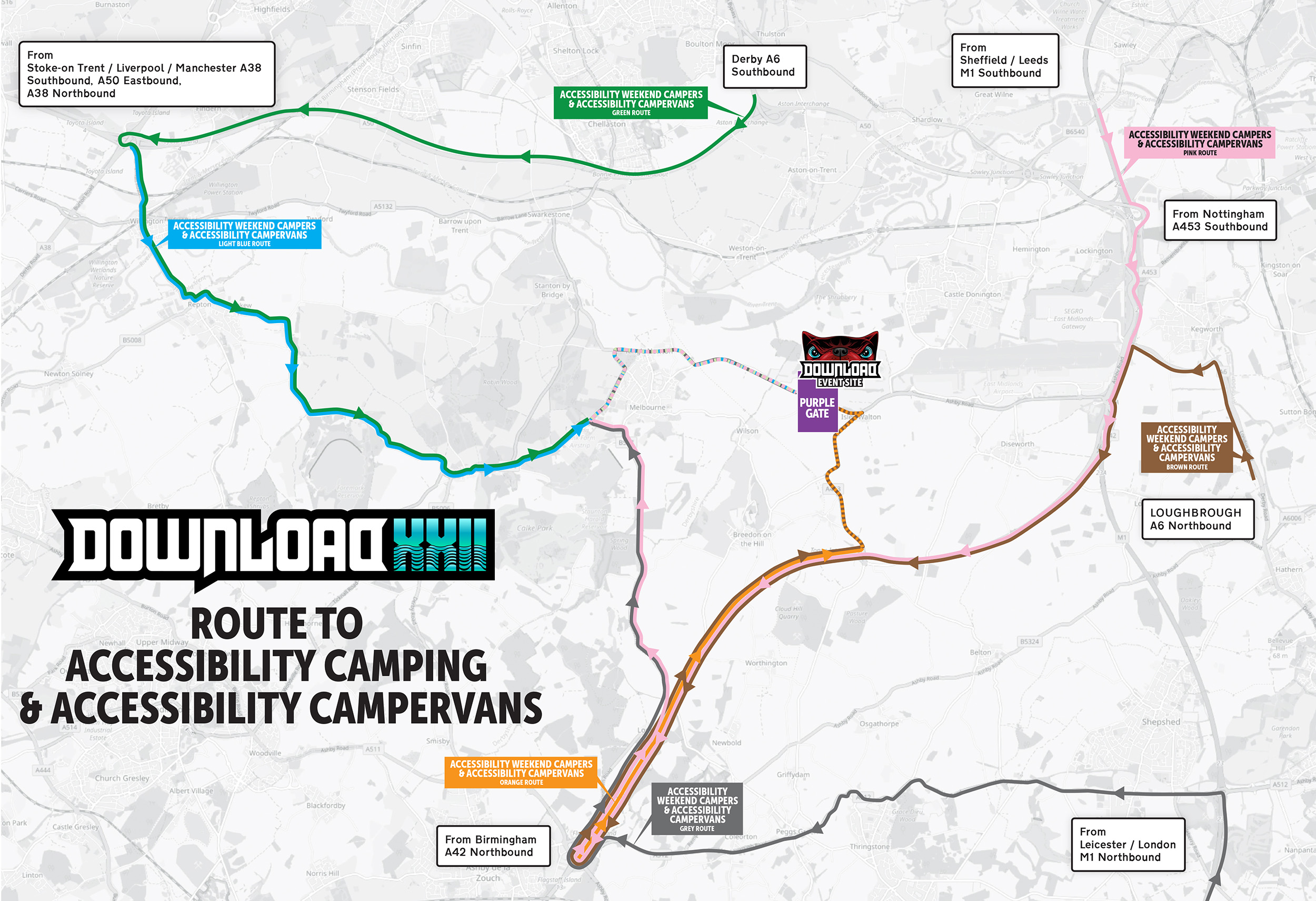
| Travelling from... | Route colour | Head to camping & campervans (accessibility) |
|---|---|---|
| The Northwest via Stoke-on-Trent / Liverpool / Manchester (A38 Southbound / A50 Eastbound / A38 Northbound) | Light blue | Apple Maps / Google Maps |
| Derby via A6 Southbound | Green | Apple Maps / Google Maps |
| The North via Sheffield / Leeds / M1 Southbound / A1 Southbound | Pink | Apple Maps / Google Maps |
| The Northeast via Nottingham / A543 Southbound | Pink | Apple Maps / Google Maps |
| The Southeast via Loughborough / A6 Northbound | Brown | Apple Maps / Google Maps |
| The South via Leicester / London / M1 Northbound | Grey | Apple Maps / Google Maps |
| The Southwest & Midlands via Birmingham (A42 Northbound) | Orange | Apple Maps / Google Maps |
Accessibility day tickets & weekend arena driving routes
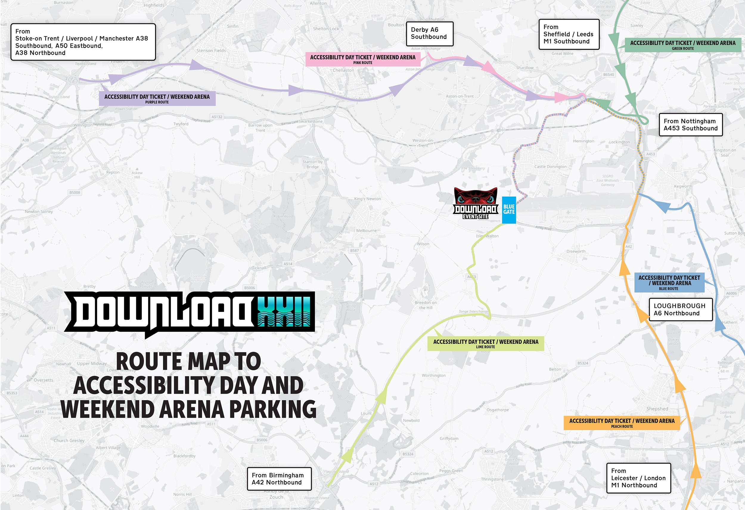
| Travelling from... | Route colour | Head to day & weekend arena (accessibility) |
|---|---|---|
| The Northwest via Stoke-on-Trent / Liverpool / Manchester (A38 Southbound / A50 Eastbound / A38 Northbound) | Purple | Apple Maps / Google Maps |
| Derby via A6 Southbound | Pink | Apple Maps / Google Maps |
| The North via Sheffield / Leeds / M1 Southbound / A1 Southbound | Green | Apple Maps / Google Maps |
| The Northeast via Nottingham / A543 Southbound | Peach | Apple Maps / Google Maps |
| The Southeast via Loughborough / A6 Northbound | Blue | Apple Maps / Google Maps |
| The South via Leicester / London / M1 Northbound | Peach | Apple Maps / Google Maps |
| The Southwest & Midlands via Birmingham (A42 Northbound) | Lime | Apple Maps / Google Maps |
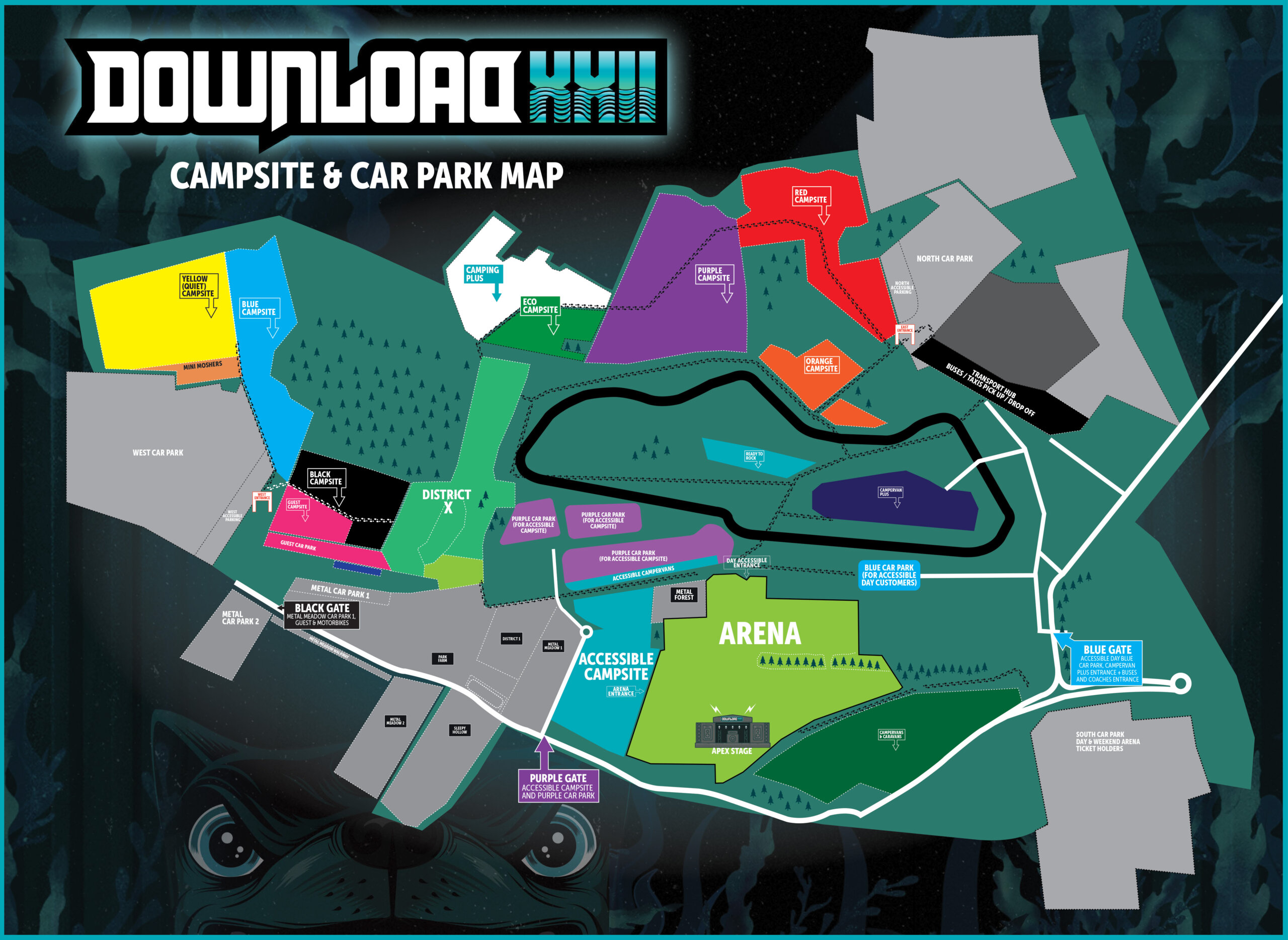
Where to park
The table below outlines where you should park based on your ticket type. Please follow your designated route map and road signage that will ensure you arrive at the correct car park.
| Type of ticket | Car park |
|---|---|
| Quiet, Mini-Moshers, Lone Wolf Camping & Motorbike Parking | West car park (contains dedicated accessible parking) |
| General, Eco, Group Camping & Camping Plus | North car park (contains dedicated accessible parking) |
| Day and Weekend Arena Only Tickets | South car park |
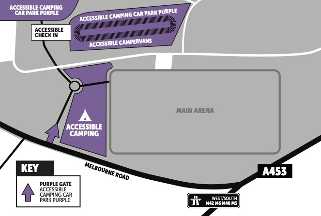
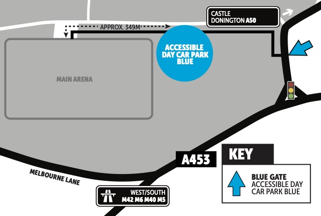
| Accessibility Day and Accessibility Weekend Arena Only Tickets | Accessibility Day Blue Car Park |
| Accessibility Camping | Accessibility Camping Purple Car Park |
| Campervan Plus | Follow yellow signs to Blue Gate |
Arriving by car
Once you arrive in the car parks, please follow the directions from the parking stewards to ensure everyone can be safely parked and the car park is fully utilised. Please ensure your car park pass is visible in the windshield of your vehicle.
Accessible parking can be applied for alongside other facilities. Accessible parking for campers is in the Purple Car Park. Accessible parking for non-camping customers is in the Blue Car Park. Please note that the Purple Car Park is now at capacity. There is additional accessible parking in both the West and North car parks. Car parks are shown on the Campsite and Car Park Map. If you have applied for accessible facilities, you will be contacted with more information regarding your parking. For information on how to apply for accessible facilities, please visit our accessibility page.
Arriving by motorbike
If you are parking in the motorbike parking, your ticket will be scanned on entry and you will be issued with a wristband that can be attached to your vehicle.
FAQs
When can I arrive?
- The North and West car parks are open from Wednesday 11th June at 7am. The South car park will open on Friday 13th June at 7:30am
- Remember the campsites don’t open until 12 noon and there will be no facilities other than toilets until you reach the campsites so it’s a good idea to eat before you arrive, have some water and have any required medication with you.
- Looking to car share? Sign up to Download Liftshare.
How do I get back to my car?
- Please ensure you make a note of where your car is parked.
- You can drop a pin on your phone or save your What 3 Words location to remind yourself.
How do I leave the festival?
- You will be directed out of the festival site by the traffic team, please follow their directions to allow everyone the smoothest journey out of the site.
- All major roads will be signposted once you have exited the site.
- You can leave the festival at any time, however the campsite closes at 12 noon on Monday 16th June.
Where can I get the latest travel updates?
- Download the festival app on IOS or android and follow our travel updates page for the latest travel updates.
- We will also communicate important updates on our social media channels.
If you have any queries on the above, please do not hesitate to contact our team at info@downloadfestival.co.uk